When I was growing up I hated geography, especially world geography. I had the most difficult time learning countries and their capitals. It didn’t help that parts of Europe and Africa were engaged in civil war, which meant the formation of new countries, adding to my work. My middle school world geography class created a lasting disdain for maps and geography in general. Maps weren’t important to me until I got serous about Bible study. With so many ancient cities throughout the Bible, Bible maps were the only way I could keep up.
Today, I want us to take a look at Bible maps, a vital resource for Bible study. Many scoff at them, much like I did with my world geography class, because they don’t see their utility. Well, I want to show you there’s a whole side of the Bible you’re missing without the use of Bible maps.
In this tip we’ll take a look at the different types of Bible map products, some reasons why you would use them, as well as a few of my favorite maps resources. So, let’s dive in!
Types of Bible Map Products
Bible maps can be found in all sorts of places. But, that doesn’t mean all maps are created equal. Some are barely passable or useful, while others will blow you away with their quality and detail.
Here are some products that contain Bible maps.
Note: the quality of the maps in any given resource varies from publisher to publisher and from product to product. Take note of the maps’ quality before making your purchase. Don’t waste money on maps that don’t give you what you need.
Not all Bible maps are created equal. Make sure they're good quality before spending your hard earned money. Click To TweetThe Back of Your Bible
This one is a no brainer. If you own a physical Bible, it likely has a few maps in the back. Without spending a dime on additional resources, these maps are often useful and worth taking a look at when you get stuck in your studies.
My Schuyler Quentel ESV Bible has the following maps:
- The world of the patriarchs
- Israel’s twelve tribe allotments
- Route of the Exodus
- Kingdom of Saul, David and Solomon
- The divided kingdom
- Assyrian and Babylonian empires
- Persian and Greek empires
- Ministry of Jesus
- Jerusalem and the passion of the Christ
- Apostles’ early ministry
- Missionary journeys of Paul
- Roman empire and early Christianity
That’s quite the number of maps, and they are high quality. For most of my studies I need look no further than these. The same could be true for your Bible.
Maps in Commentaries, Study Bibles, and Bible Surveys
The next place you should look for maps is in your commentary or study Bibles. Other biblical resources like Bible surveys and overviews are also key places to find maps. The maps in these resources are often contextualized to the content being discussed, making them more useful than the maps found in the back of your Bible.
Now, the Bible maps found in commentaries usually aren’t the greatest. Their focus is explaining the text, so they aren’t as concerned with providing visuals. That’s not to say that there aren’t some commentaries that realize their importance and provide quality maps. Study Bibles and Bible surveys, on the other hand, often include maps throughout the text to help you better understand and visualize the biblical narrative.
The ESV Study Bible is one of the best study Bibles in this area. Its maps were best in class when it originally released in 2007, and it continues to have some of the best maps in any resource. The NIV Zondervan Study Bible is another with spectacular maps.
Books of Maps & Charts
Once you get beyond study Bibles and commentaries, you get into the realm of specialized Bible map resources. Books of maps and charts are the first type of resource in this category. If you want maps, you’ve got it. These books are often nothing but maps and charts giving you a lay of the land. Don’t expect to find much, if any, commentary on the text in these resources, just maps.
The one downside to these tools is their specialized nature.
Rose Publishing is best known for their Bible maps & charts products. Check out their resources if a book of maps is what you need.
Bible Atlas
The next and type of Bible map product is a Bible atlas. The best way to describe a Bible atlas is to think of your geography textbook from your school days. Essentially, it’s a book of maps & charts with commentary explaining the context of the visuals. Bible atlases also include lots of pictures, giving you a modern look at many biblical sites.
If you’re serious about using maps in your study, a Bible atlas is something you’ll want to add to your library. It’s an invaluable resource for geographical and background information in your Bible study.
A Bible atlas is your textbook to understanding the Bible's landscape. Click To TweetReasons to Use Bible Maps
Bible maps can be used for more than simply finding a locale on a map. Here are a few ways you can use them in your studies.
Determine Distance
Distance is important. We want to make sure we don’t live too far from work or family. How many miles is that road trip? Even our fitness activities take distance into account. Yet, for all this, we take distance and travel for granted, especially when we factor in modern transportation. But, distance is important to biblical studies and was very important for those who lived in Bible times.
Take a moment and think about it. Right now I live about six miles from my office. Driving in my car, with traffic, I can be there in 15 minutes, 20 max. Now imagine if I walked that route. If I walk at a leisurely pace, it would take about 2 or 3 hours to get there. That’s a significant difference in time! Now if my wife were to do the same, her time would be tripled because she’d have to go 3 times as far!
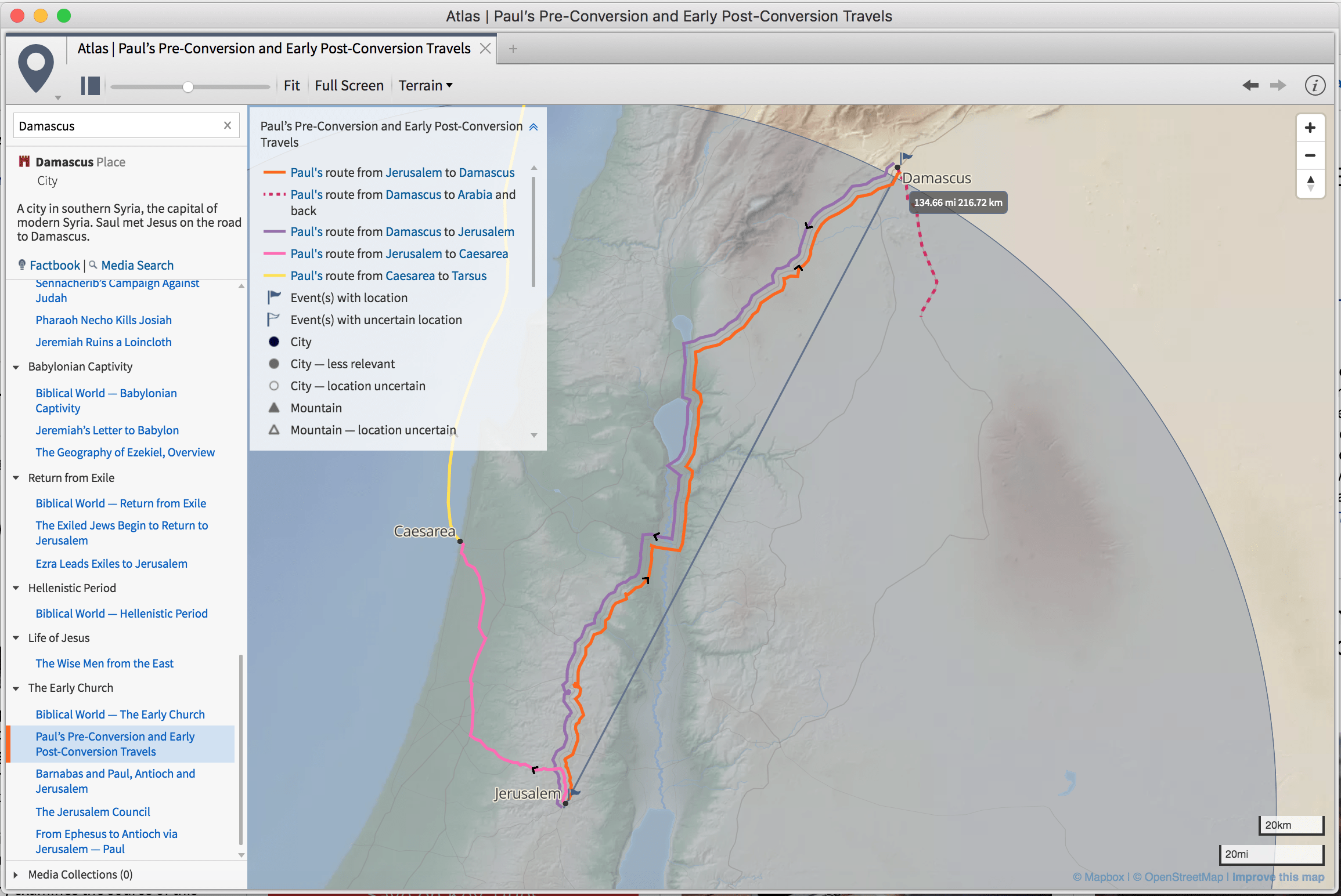
I say that to put the Bible into perspective. During Jesus’ final week in Jerusalem, consider his nightly 1.5 mile walk to Bethany. That was probably a nice stroll in and out of the city. How about Paul’s journey to Damascus (135 miles)? That trip took Paul & his men several days by horseback, making camp who knows where each night. By comparison, that trip would only take us a few hours in a car, depending on the speed limit.
As you can see, distance becomes far more important when you consider the biblical narrative. And this is one area where maps can help us. Instead of merely noting the location of cities on a map, we can calculate the distance between them, and consider the time needed to cover such distances. This is the type of information we can find when we use Bible maps.
Distance is something we take for granted but travel was completely different in biblical times, and is thus important for study.
Distance might not mean much today, but it was a BIG deal in Bible times. Click To TweetTopography
Have you ever wondered why the Bible talks about people going “up to” or “down from” Jerusalem? Topography answers this question.
When we look at Jerusalem on a topographical map we see that it has a higher elevation than most things around it. It was a city on a hill (Daniel 9:16). Therefore, to go to Jerusalem meant you going “up to” it, even if you were coming from the north heading south. And when you leave the city you’re going “down from” the hill on which it sits. It is little things like this that we can learn from these kinds of maps.
Topographies help us see the land in a more three-dimensional fashion. With them we can better see valleys and mountains. Having this information in hand, we can better visualize how the Bible’s characters navigated the terrain. This information is lost to us without these kinds of maps.
Borders
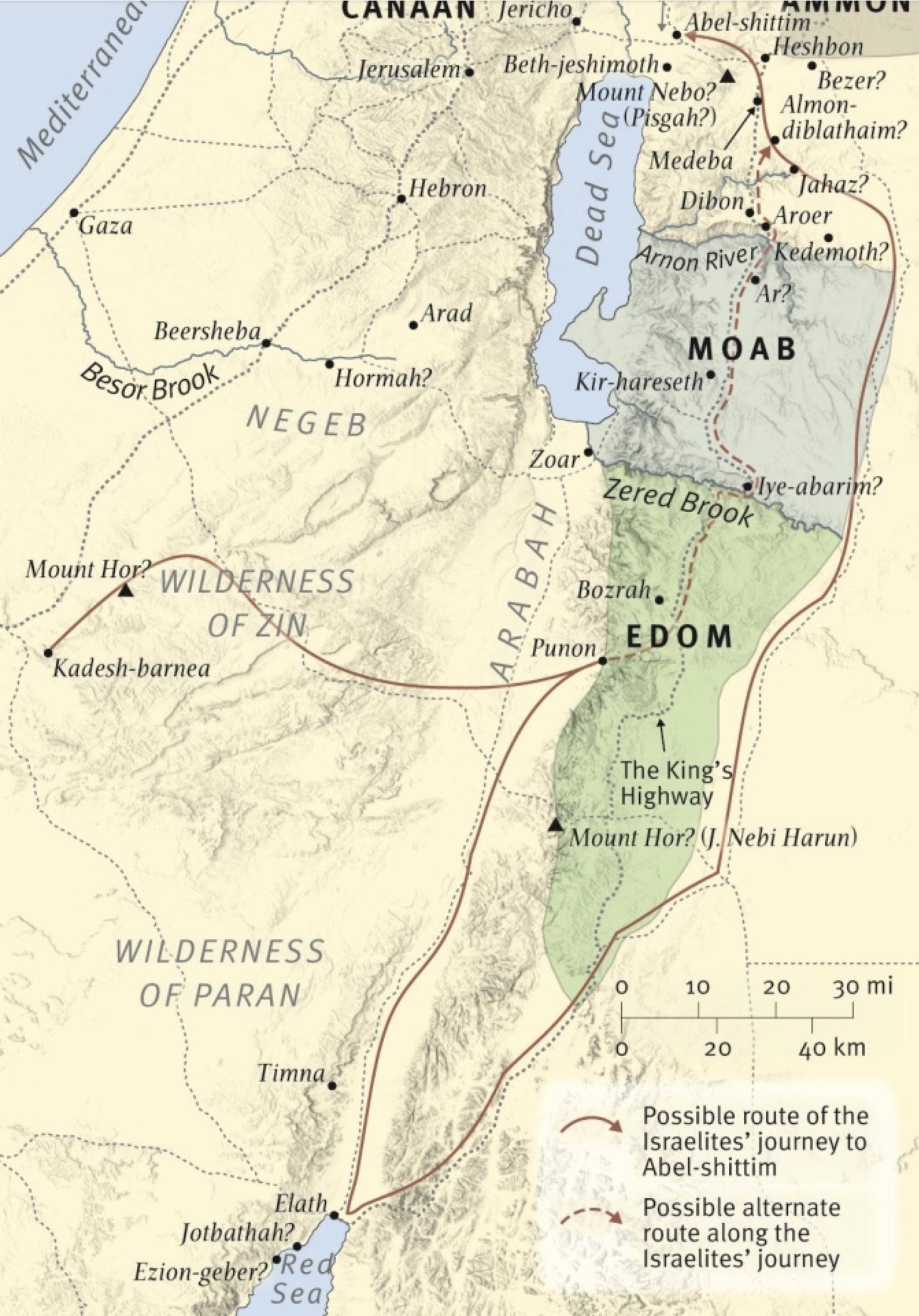
Bible maps are also helpful when it comes to figuring out the borders between nations. In modern times the only way we know where one state or country ends and another begins is with a map. There are no painted lines depicting such borders. Well, the same is true of biblical times. We need Bible maps if we’re going to know where the territory of the Moabites or the Edomites was located. A good Bible map will show us these borders.
Borders are helpful when looking at things like the Exodus. Maps that depict borders will show the different nations or kingdoms Israel had to pass through on their way to the Promised Land. Such maps are also helpful for visualizing the expanse of larger nations like the Babylonian and Roman empires, seeing just how far their rule reached.
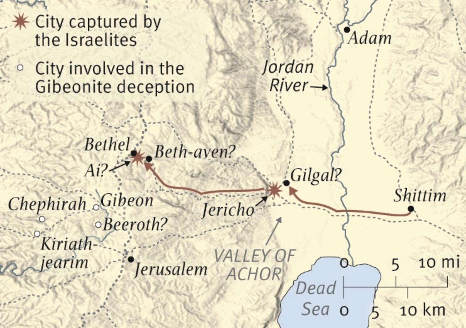
Illustrated Maps
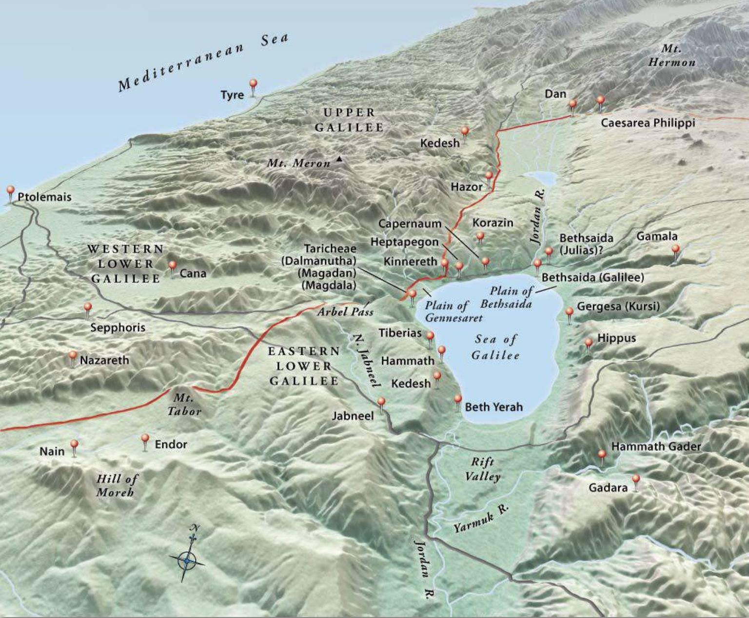
Of all the maps, illustrated maps are probably the most helpful. These are the maps that show you the routes of travel or where certain battles took place.
For example, this is the type of map that charts out Joshua’s conquest of the Promised Land, showing the route he took and where each battle was fought. Another great map would be David’s travels while fleeing from Saul, seeing how far he traveled and where he was each step of the way.
These maps are helpful because they orient the Bible’s events with the geography so you can picture how everything took place without having to plot it out yourself. Without these maps, I would be lost in most of my Bible study.
Bible Maps Recommendations
There are lots of Bible maps products on the market, and I want to share some of my favorites with you. I use the products listed below on a regular basis in my studies and find them to be extremely helpful.
ESV Study Bible
When I don’t want to carry around or use a lot of books, the ESV Study Bible is my go to resource. No matter what I’m studying, I can expect to find a map that helps me visualize what’s happening in the text. The beauty is that I don’t have to go searching for it, as it’s always right there with the passage I’m reading. And if it’s not inline, it’s in the book’s introduction or in the back.
ESV Bible Atlas
For those times I need to dig deeper, the next resource I turn to is the ESV Bible Atlas. The layout of the content makes it easy to find what I’m looking for. It is organized into three (3) main sections. First there is a general introduction & overview of the biblical world. These maps focus on things like climate & vegetation, topography, and other natural features. The second part breaks down the maps into a historical geography. Here the maps & commentary are divided into historical periods, intertwining the biblical world with the rest of world history. The final section focuses on different biblical regions, looking at each in-depth.
When you need more than a map, this is a great resource to help you quickly understand the history and geography of any area or era.
Zondervan Atlas of the Bible
The Zondervan Atlas of the Bible is a great supplement or alternative to the ESV Bible Atlas. It is another I use frequently in my studies. The content is organized by history, making content very easy to find.
You really can’t go wrong with either resource.
Google Maps & Google Earth
Finally, I like to use Google Maps. Sometimes you need to compare the biblical world to the present, and Google Maps makes that an easy task. You can quickly view present day borders, get distances between cities, turn on a satellite view, and so on.
If you want to go further, there are biblical overlays for Google Earth. These allow you to use Google’s satellite imagery and functionality while viewing the biblical world. You can find more information here. This alone makes Google Maps/Earth an indispensable tool for Bible study.
Take Your Maps Digital
While I’m talking about my preferred resources, let me tell you that I own zero physical Bible maps resources. All of the Bible maps products I own are digital, and I would strongly suggest you consider the same. Here are a few brief reasons why:
- All your maps are a search away. Many Bible apps index each map’s content so you can easily find all the maps that mention your search terms. In a matter of seconds you can find every map in all resources that has Caesarea Philippi.
- Maps are brought to you. When you use an app like Olive Tree, Accordance, or Logos, you often don’t even have to go searching for the content. As you study a passage the information you need is brought to you. For example, Olive Tree’s Resource Guide will surface any map that contains locations contained in the passage you’re studying. This makes maps even easier to use.
- Zoom & Pan. Unless you plan on pulling out a magnifying glass, there’s only so much you can see on a physical map. Yet, Bible apps allow you to zoom and pan for easy and up-close viewing.
Sure, there are more reasons why I use digital Bible maps, but the bottom line is they are easier to use and cut out much of the legwork of manually flipping pages to find (or not find) what I’m searching for.
Find Your Way
By now you should be convinced of the usefulness of Bible maps for your Bible study. They open up the biblical world in a way that nothing else can, and a way that so many ignore.
Next time you’re studying a narrative passage of Scripture, pull out a Bible map, get acquainted with the landscape, and put yourself into the text. And if you need a Bible map or atlas, don’t delay in adding one to your library!
Weekly Study Prompts
This week, meditate and journal on the following passages:
- Monday – 2 Kings 17-18
- Tuesday – 2 Kings 19-21
- Wednesday – 2 Kings 22-23
- Thursday – Jeremiah 1-3:5
- Friday – Jeremiah 25; 29
- Memory Verses: Proverbs 29:18; Jeremiah 1:15